
Bryce Canyon Country: Nevada: USA
 Bryce Canyon Country
Giant chess pieces? Soaring sandcastles? Monks turned to stone? Not at all — just another of nature’s masterpieces, the magical place called Bryce Canyon.
To one explorer, it resembled “a mighty ruined colonnade.” To an early settler, Ebenezer Bryce, it was “a hell of a place to lose a cow.” But to the thousands of annual visitors to Bryce Canyon National Park and the surrounding area, it is quite simply unforgettable.
State Route 12, an All American Road, and other nearby scenic byways take you deep into this city of stone and beyond, where time, water, and the elements have fashioned a soul-stirring landscape of fairy-tale castles and ramparts.
Red Canyon
Heading east across sagebrush flats, the drive quickly enters seven-mile-long Red Canyon, which offers all the dramatic splendors of Utah’s canyonland in miniature.
The canyon was carved by the same erosive forces that created Bryce and boasts stunning scenery of its own. But one big difference prevails: this little jewel of a canyon is far less visited than its big brother, so its trails remain virtually pristine.
A U.S. Forest Service visitor center at the west end of the canyon directs visitors to a separate trail network that caters to human-powered and motorized forms of recreation. Many of Red Canyon’s prettiest vistas can be seen along Rte. 12, which burrows through terra-cotta tunnels as it heads east.
Slicing across Dixie National Forest, the drive passes glistening ponderosa pines and twisted stone formations tinted pink and scarlet by iron-rich minerals.
Dixie National Forest
In a region dominated by desert, water is a precious resource. That makes Dixie National Forest a valued neighbor. Were it not for the mountains and plateau tops of this forest, nearby cities and towns would never have been able to flourish.
Throughout the winter, snow accumulates at high elevations, later melting into mountain streams that feed sparkling lakes. State Rte. 22, one of several roads on which you can explore the forest, leads to the turnoff for Powell Point.
Watch for Rte. 132 to Pine Lake Campground, but climb to the top of the plateau beyond the camp only if you have a high-clearance all-wheel-drive vehicle. Some 10,000 feet above sea level, this promontory looks out on the red-and-pink cliffs of the Claron Formation below and, beyond it, Arizona.
Animal lovers may opt to drive the East Fork of the Sevier River Scenic Byway, a must for wildlife viewing; look for Rte. 87, about 11 miles east of the Rte. 89 and State Rte. 12 junction. From its numerous pullouts, sightings of pronghorns, prairie dogs, and jackrabbits are more than likely, and in summer and autumn, perhaps an elk will saunter into view.
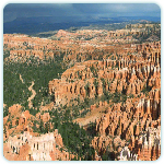
Bryce Canyon National Park
The first thing to be said about Bryce Canyon is that it’s not a canyon at all. Extending for 18 miles along the eastern edge of the Paunsaugunt Plateau. This enchanting fairyland of stone is a series of huge, horseshoe-shaped amphitheaters, carved over millions of years by countless rivulets.
Time, wind, and water — that masterful team of sculptors — also collaborated to create one of the park’s most popular attractions: the fanciful rock formations known as hoodoos.
The intense palette to be savored here makes this 36,000-acre national park one of the most photogenic in America. The rocks’ vivid hues have been created by the oxidization of various minerals.
Making this kaleidoscope of color even more dramatic are the vast backdrops nature has provided for contrast: thick stands of evergreens and a seamless sky of cobalt blue. Perhaps some of this grandeur can be gleaned from photographs.
But only those who see Bryce Canyon for themselves can forgive the excess of exuberance displayed by one early surveyor of the park, who described it as “the wildest and most wonderful scene that the eye of man ever beheld.”
Bryce Canyon Scenic Drive
The beauty of Bryce Canyon can be sampled along an 18-mile drive that traces much of its rim. Scenic overlooks — many with views that on a clear day extend 100 miles or more — provide plenty of opportunities for picture taking or wandering along some of the park’s 61 miles of trails.
Before venturing into the canyon, stop at Ruby’s Inn, an al-purpose facility just north of the visitor center. There you can buy supplies, rent mountain bikes, cross-country skis, and horses or arrange a helicopter ride over the park’s scenic wonders.
Once inside the park, head for the turnoff to Bryce Canyon’s main amphitheater, which is ringed by four accessible and drop-dead gorgeous viewpoints plus the salmon-tinged hoodoos that stand within.
By following signs to Sunrise Point, you’ll be able to drive or walk to Sunrise, Sunset, Inspiration, and Bryce points. At Sunrise Point hike the Queen’s Garden Trail, a short trek into the canyon below. At Bryce Point try the two-mile-long Hat Shop Trail.
The park’s main road continues south six miles to Farview Point, whose high elevation offers sweeping views of the surrounding Dixie National Forest.
Higher still is Rainbow Point, several miles south, where the one-mile Bristlecone Loop Trail leads to stands of the gnarled pines. More than millennium in age, these hardy trees are the oldest living things found in Bryce Canyon.
Tropic Canyon
The six-mile drive through this scenic canyon, found just north of Bryce, passes among more rock formations as it wends its way east to Tropic. The town is home to Ebenezer Bryce’s robust collection of Indian and pioneer artifacts.
Kodachrome Basin State Park
About seven miles south of Cannonville, a spur road leads to Kodachrome Basin State Park, where the scenery is as vivid as the park’s name implies. Sixty-seven spires of rust-colored sandstone soar skyward like frozen geysers.
The surrounding landscape is laced with numerous hiking trails. They range in difficulty from the quick-and-easy Nature Trail to the Eagle’s View Trail, where intrepid hikers who climb a steep one-mile path are rewarded with heavenly vistas.
Southeast of the park the 37-mile-long Cottonwood Canyon dirt road takes you past Grosvenor Arch. You have now entered the Grand Staircase-Escalante National Monument, one of the most remote regions of the American Southwest.
This area is a favorite among locals, but bring plenty of provisions and a current weather forecast — changes in the weather, including snow and flash floods, can be life-threatening — always come prepared for a long, cold stay.
Escalante State Park
Strewn about the landscape of this 1,400-acre desert park are an abundance of ancient fallen logs that, through the magic of nature’s alchemy, were slowly transformed into stone. Located just west of the town of Escalante, the park displays its colorful collection of jewels along an interpetive trail.
Geologic history is explained at a visitor center. At nearby Wide Hollow Reservoir, rimmed with cottonwood trees, activities include swimming, fishing, and canoeing. Continuing eastward on State Rte. 12, the drive connects with several scenic side roads. The Posey Lake Scenic Backway, just north of Escalante, passes Posey Lake, ringed by ponderosa pines.
As you reach Hell’s Backbone Road, a challenging ride leads to Hell’s Backbone Bridge and stupendous views into the heart of Dixie National Forest and Grand Staircase-Escalante National Monument. Another regional route, the Hole-in-the-Rock Scenic Backway, takes off from State Rte. 12 five miles east of Escalante.
Again, a four-wheel-drive vehicle is recommended, as are ample provisions; the best sights lie far off the gravel-and-dirt road, close to the Escalante River — a territory suitable only for well-equipped hikers.
The road leads to a gap in the 2,000-foot-high cliffs. Be forewarned, though; just before you reach Hole in the Rock, the road becomes nearly impassable, and it’s best to hike. Stop at Devils Rock Garden, where hoodoos provide an offbeat backdrop for a picnic.
Calf Creek Recreation Area
There’s a surprising abundance of water in this high desert. East 15 miles from Escalante on State Rte. 12, you’ll see Calf Creek. A stiff six-mile hike leads to its lower falls, passing prehistoric ruins and rock art before reaching the pot of gold: a 126-foot-tall cascade tucked away in a shady cul-de-sac. Dip your toes into the pure, icy waters of the pool at the bottom as your reward.
Boulder
Continuing north to Boulder, the drive crosses the Hogsback, a narrow ridge with steep cliffs on either side. Just south of town lies the 66-mile Burr Trail, which retraces the century-ago steps of pioneer rancher John A. Burr. At Boulder, head for the Anasazi Indian Village State Park, a museum and partially excavated settlement that, over the years, has revealed pottery shards, axe heads, and other artifacts. While Boulder may feel as though it sits at the end of the earth, it’s actually a quaint, accommodating ranch town with surprisingly good restaurants.
Boulder Mountain
Paying a return visit to Dixie National Forest, Rte. 12 climbs across a cool mountain landscape endowed with silvery aspens and sweetly scented evergreens. Atop the 9,670-foot-high summit of State Rte. 12, enjoy views of the 100-mile-long Waterpocket Fold monocline within Capitol Reef National Park to the east and south. From the elevated vantage points of this easternmost segment of the drive, the austere beauty of Utah’s canyon country is laid bare for all to see — a sprawling monument to the power of water.