
Mt. Shasta-Cascade Loop: California: USA
 Mt Shasta Cascade Loop This drive visits sky-shearing volcanoes, flourishing forests and wetlands that teem with life, and even otherworldly underground chambers.
Redding
Nestled in the northern reaches of the Sacramento Valley, Redding boomed in 1872, when the railroad was built. The city serves today as a gateway to the surrounding wilderness. Its streets offer hotels, restaurants, shopping, museums, Turtle Bay Exploration Park, and the all-glass pedestrian Sundial bridge. Preview the area’s wildlife and enjoy quiet strolls on the Sacramento River Trail. A leisurely 9.5-mile loop through riverside oak groves, the pathway is full of the sights and sounds of many species of colorful songbirds.
Shasta Lake
The drive heads due north on I-5 to Shasta Lake, a favorite of both boaters and water-skiers. Shaped like an oddly fingered hand, with each digit stretching toward an incoming river, the lake was created by Shasta Dam. Massive and imposing — its spillway rises 487 feet — the dam ranks as one of the nation’s largest concrete structures. The lake’s zigzagging shoreline is a mix of red-clay cliffs and foothills cloaked with pines and manzanita. To visit the dam, take Shasta Dam exit 7 miles north of Redding on I-5, and continue through the city of Shasta Lake. Shasta Dam Blvd. will lead you to a panoramic view of the region.
Lake Shasta Caverns
Five miles beyond the turnoff to Shasta Dam lies the small community of O’Brien, the jumping-off point for tours of these caverns — a cache of hidden beauty that rivals the area’s more conspicuous wonders. The trip begins with a 15-minute ferry ride across Shasta Lake, followed by a short hop on a bus that climbs to a simple, nondescript door. Behind it, though, lies a surreal display of geologic art: an interior adorned with fluted columns, white spires, and crystallized stalagmites — all built slowly, drip by drip.
Castle Crags State Park
With the Trinity Mountains to the west, the interstate leads to Castle Crags State Park, where huge dome-topped granite spires rise more than 4,000 feet above the Sacramento River. Hoping to strike it rich, gold diggers once prospected here, but today the treasures are strictly scenic. Trails lead sightseers to the foot of the impressive peaks and weave through the area ‘s forest, overgrown with Douglas firs and incense cedars.
Dunsmuir
On the way to Dunsmuir, I-5 continues alongside the Sacramento River, which courses through brush-covered canyons beside the Southern Pacific Railroad. The trains that steamed through here were instrumental in the town’s growth, and an old railroading center offers visitors a glimpse of those earlier days.. Dunsmuir is also known for its drinking water, which comes from an underground spring and is bottled for nationwide export. Take a sip at one of the public fountains, then decide whether or not the town’s nickname, Home of the Best Water on Earth, is truly deserved.
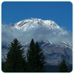
Mt. Shasta
Shasta’s great peak — visible from m o re than a hundred miles away — beckons travelers along much of this drive. Cresting at 14,162 feet, Mt. Shasta is a delight to behold and an inspiring monument to the volcanic past. For a closer look and an eagle’s-eye view of the region, follow Everitt Memorial Highway (Rte. A-10), which makes a relatively easy climb nearly halfway to the glacier-clad summit. Scientists explain that Mt. Shasta’s great bulk — its base spans a distance of 17 miles — has contained within it at least four separate volcanic cones. The mountain’s fairly symmetrical shape was formed over the centuries — some speculate 100,000 years were required — as one eruption after another discharged lava, with later flows coming to rest atop earlier ones.
Klamath National Forest
After passing a steep-sided volcanic cone called Black Butte, I-5 enters the welcoming town of Weed, once a busy lumbering center notorious for its brawling inhabitants. The drive then heads northeast on Rte. 97, making a gradual climb into the Cascades and the Klamath National Forest. Visit the Living Memorial Sculpture Garden, 13 miles east of Weed, or simply enjoy the route’s natural attractions. Vast and diverse, the forest includes juniper, ponderosa pine, incense cedar, and shrubs such as sagebrush and rabbitbrush. After topping out at Mt. Hebron Summit, the road descends between volcanic mountains. On the way, you’ll cross old lava flows, then eventually enter Butte Valley, a sweeping expanse that was once all lake; today it is a huge depression, spotted with marshes and farms and encircled by sage-covered hills and high peaks.
Lower Klamath Lake
Just a bit south of Oregon, the drive turns east, following Rte.161 to Lower Klamath Lake, part of Lower Klamath National Wildlife Refuge, among the world’s best sites for viewing bald eagles. One of the world’s greatest nature-watching locales, the area teems with literally millions of birds — some 400 species in all. Although each season offers something special, spring and fall get the highest concentrations of birds, with huge flocks of waterfowl filling the sky. Unpaved roads (bird-watchers can use their cars as blinds) loop through the refuge, offering views of the display, which includes ducks, geese, swans, grebes, pelicans, herons, hawks, and eagles. To the east Tule Lake National Wildlife Refuge offers more of the same, so be sure to bring your camera and binoculars.
Lava Beds National Monument
Switch onto Rte.139 south, which passes through Tule Lake, then leads to the well-marked turnoff to Lava Beds National Monument, one of the stops on the Volcanic Legacy Scenic Byway, an All- American Road that continues down Rte. 49. After skirting the southern shores of Tule Lake, the road passes through a region that was once scorched under sinuous rivers of lava, which cooled into an array of formations, including bluffs and caves. On the area’s younger rocks — some about a thousand years old — lichens have gained a toehold, the first step in transforming the stones into soil. Eagles and hawks — their aeries safely hidden among the cliffs — might be seen soaring above. On land deer and pronghorns share living space with stealthier animals such as marmots and foxes. Stop by the national monument’s visitor center, complete with interpretive displays, for helpful information.
Ash Creek Wildlife Area
After returning to Rte. 139, the drive passes through an isolated wilderness, where the facilities are few and scattered. To the east o f this area lie the vast high deserts of California and Nevada. B e f o re the town of Adin, the highway again climbs into the mountains and crests at 5,188 feet. Black basalt and gray ash — more reminders of past volcanism — can be seen along the way. Grazing grounds and alfalfa fields then come into view, and just off the highway at Ash Creek Wildlife Area, some 14,000 acres offer yet another bird-watcher’s haven.
Fall River Mills
Fly-fishing connoisseurs rave about the spring-fed brooks outside Fall River Mills, a mountain town perched at an elevation of about 3,400 feet. In the mid-1800s a pair of mills operated here, one a sawmill for processing lumber, the other a gristmill for making flour. Exploring the local streets, visitors can take in an old blacksmith shop and jail at Fort Crook Museum, which also houses exhibits of the pioneers and native American artifacts.
Burney Falls
Eleven miles beyond Fall River Mills, turn north onto Rte. 89 for the start of a six-mile journey to Burney Falls. Trails lead to the 129-foot cascades, which in the wetter months are watery plumes that burst from a cliffside. When the conditions are right, rainbows color the rising clouds of mist. For that very reason, perhaps, the local Ilmawi Indians allowed other tribes to camp beside the falls, the only part of their territory where such an intrusion was permitted.
Lassen National Scenic Byway
After a quick turnaround, head south on Rte. 89, which runs through the Hat Creek valley and Lassen National Forest. A lengthy, steep rim — visible evidence of a fault in the earth’s crust — juts up just to the east. At the junction with Rte. 44, turn toward the east on the first leg of the scenic byway. This superb route passes myriad volcanic remnants and provides access to many trails, which lead to lakes and fine views of the forest. The soil in this region supports a variety of different trees. A list of the various species includes ponderosa pine, lodgepole pine, red fir, white fir, and Douglas fir. Aspens also grow here, surviving in areas that have relatively high amounts of moisture, such as creek banks and along the fringes of open meadows. At Rte. 36, a turn to the west leads to Lake Almanor, a restful vacation spot. The dome of nearby Lassen Peak reflects on the water’s often mirrorlike surface.
Lassen Volcanic National Park
Few national parks can illustrate with as much clarity the fact that the earth’s surface is forever changing. Rte. 89 — which leads to the visitor center and viewing areas — snakes through skirting steam vents, boiling mudpots, gaseous fumaroles, and cone-shaped mountains of cinder and ash.. Boardwalks lead to many of the sites, and visitors are advised to stay on the trail, for parts of this region where the earth’s molten interior escapes to the surface have been known to collapse. A shining example of nature ‘s power is Lassen Peak, which last erupted for seven years beginning in 1914 and is the park’s tallest volcano, cresting at 10,457 feet — yet another showstopper in a national park that, despite its unsettled volcanic past, offers a relaxing escape at one of the national park system’s best — kept secrets.