
Western Region: California: USA
 California is home to thousands of people who work in the TV and motion picture industry. Many of the TV shows and movies made in the United States are filmed in movie studios that are located in the Los Angeles area. The ancient Bristlecone Pine trees that grow in the Inyo National Forest are believed to be approximately 4,600 years old. That would make them the oldest living things on earth! California For all its popularity as a travel state, the Golden State still has many interesting and attractive out-of-the-way places to savor.
 Feather Falls Scenic Area
Feather Falls Trailhead Rd., Oroville, California
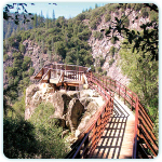
Visit the three tiers of Feather Falls during spring or fall and hike the seven-mile round-trip for a breath-taking colorful view. Gleaming like a glass skyscraper, the three tiers of Feather Falls plunge 640 feet into a valley cut into the Sierra foothills.
Hikers can take a moderate-level well-marked trail leading through sparse manzanita and pine chaparral to an observation deck with a spectacular top-to-bottom view of the falls. Hikers should plan on an afternoon to make the seven-mile round-trip and be sure to carry plenty of water.
The best seasons to visit are in the spring, when wildflowers provide a painter’s palette of colors, and in autumn when the trees are adorned with reds and golds. The scenic area, which encompasses 15,000 acres in the Plumas National Forest, includes a number of other hiking trails, scenic spots, and campgrounds.
The three branches of the Feather River (whose middle fork is fed by the falls) afford some of the most challenging whitewater rafting in the state. Downstream are calmer stretches of water for canoeing or kayaking. –Open year-round.www.r5.fs.fed.us/plumas (530) 534-6500
 Prairie Creek Redwoods State Park
127011 Newton B. Drury Pkwy., Orick, California
View acres of the one-of-a-kind redwoods–Sequoia sempervirens. Driving north on Rte. 101, travelers are almost certain to notice the sudden appearance of the majestic Roosevelt elk in Boyes Prairie near the park headquarters and visitors center. A display at the center features a month-by-month account of the life cycle of this magnificent tree—the largest in California.
Another entire room is devoted to the ecology of the mighty redwoods, for instance. The 14,000-acre park is a preserve for these trees (Sequoia sempervirens), the tallest species on Earth. Some specimens here soar 300 feet. They and their companion plants can be seen close up on more than 30 trails that range from easy to strenuous and from one-tenth of a mile to seven miles long.
Some lead down to Gold Bluffs Beach. The James Irvine Trail, for example, is a four-mile hike through redwoods and a lush undergrowth of hemlock, laurel, and alder. It connects with the Fern Canyon Trail, where eight species of ferns cling to the steplike ledges of the canyon wall.
A herd of elk roams the beach and should be given a wide berth. They are wild and unpredictable. You can camp at the beach or near park headquarters at Elk Prairie. –Open year-round. Admission charged. www.parks.ca.gov (707) 465-7347
 Lava Beds National Monument
1 Indian Well Headquarters (off Rtes. 139 and 161), Tulelake, California
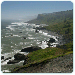
Discover lava-tube caves, purple mountains and the largest number of bald eagles south of Alaska. A vast, majestic stretch of high desert ringed with purple mountains, the monument preserves the special beauty and strangeness of land marked by volcanic activity.
From the northeast entrance the park road winds through scrubby sagebrush and rolling hills dotted with juniper and, finally, stands of yellow pine. Jagged lava rocks, deep orange in color, lie precariously amid the wispy sage.
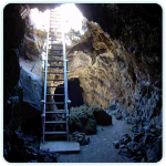
At the visitors center near the southeast entrance, information is available on the area’s turbulent volcanic origins and its plant and animal life, and a rock display illustrates the variety of minerals found here. An interpretive trail in the adjacent, illuminated Mushpot Cave explains lavacicles, spatter cones, balconies, and other formations found in the monument’s 811 lava-tube caves.
More than 15 of these are accessible from Cave Loop Rd., which begins at the visitors center. If you want to explore them, the center will lend you portable lights. The terrain once provided refuge for the Modoc people in the Modoc War of 1872–73, a Native American rebellion whose history is recounted at the visitors center.
Petroglyphs 4,000 to 6,000 years old, found on cliffs, remind one that to the Modocs this area was the center of the world. While you are here, take the Wildlife Refuge Tour along the northeast edge of the monument: The route overlooks Tule Lake in the Klamath Basin National Wildlife Refuge, frequented by literally millions of waterfowl in autumn.
Falcons and other predators congregate along the cliffs here, including the largest number of bald eagles south of Alaska. –Open year-round except Christmas. Admission charged. www.nps.gov/labe (530) 667-8100
 Ancient Bristlecone Pine Forest
White Mountain Rd., Big Pine, California
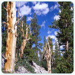
View some of the planet’s oldest living trees. Suspended eerily on the rugged slopes of the White Mountains, at an altitude of 10,000 or more feet, is a stand of one of the planet’s oldest living trees: the Great Basin bristlecone pine (Pinus longaeva).
The most ancient specimen is the 4,700-year-old Methuselah, which stands in a grove of pines that has been growing here for 4,000 years or more. The exact location of the tree is kept confidential in order to protect it. Twelve miles farther along the road that crosses the forest is the world’s largest bristlecone pine.
Here in the Patriarch Grove, at 11,000 feet, is the Old Patriarch itself, which measures more than 36 feet in circumference. The bristlecones’ tortured shapes reflect the barren, wind-swept conditions amid which they persevere, jutting out from the mountainside like bleached bones or driftwood. Many branches appear dead, while others are thickly furred with green needles.
Drippings of clear, bluish sap perfume the air. For all the seeming aridity of the land, there are lovely stands of wildflowers in the Patriarch area in August. In most weather conditions the steep road to the forest provides breathtaking views across Owens Valley to the sheer white face of the Sierra Nevada.
But after big snowfalls cars must turn back at the Sierra Vista lookout, which is at an elevation of 10,000 feet. In good weather take advantage of miles of trails and picnic grounds beautifully sited in and around this great forest. –Open daily mid-May – Oct. www.fs.fed.us/r5/inyo (760) 873-2500
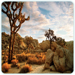 Joshua Tree National Park
7448 National Park Blvd., Twentynine Palms, California
Experience every acre of this magnificent desert. Here is the very essence of the desert: clear skies; crisp, clean, sparkling air; and some half-million acres of fascinating landforms, plants, and animals.
The area is in fact the conjunction of two deserts—the Colorado to the east and the higher, cooler, and moister Mojave in the western part of the park, where the Joshua trees grow. These strange trees—with their shaggy bark resembling a pelt of rough fur and their contorted branches resembling outstretched arms—could hardly be imagined, but once seen, they can never be forgotten.
Great jumbled mounds of gigantic rounded boulders appear randomly among the trees, adding to the surreal character of the landscape. At the park’s northeast entrance is the Oasis Visitor Center, where there is indeed an oasis—The Oasis Mara. From the center a road heads south through the Colorado Desert, where cholla cactus and scarlet-flowering ocotillo thrust their thorny limbs above patches of creosote bushes, the prevailing form of plant life here.
Near the south entrance a 71/2-mile trail to Cottonwood Spring (a man-made oasis that bird-watchers will find rewarding) leads to Lost Palms, the largest of the park’s five oases. There are nine campgrounds, mainly in the central section of the park, and a variety of hiking trails. Water is scarce, so bring your own. –Open year-round. www.nps.gov/jotr (760) 367-5500
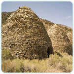 Wildrose Charcoal Kilns and Mahogany Flat, Death Valley National Park. Hwy. 190, Death Valley, California
From Wildrose campground a narrow and sometimes difficult gravel track climbs through Wildrose Canyon to Thorndike Campground at 7,400 feet, near which looms a strange colony of what look like giant beehives or prehistoric dwellings.
These are the Wildrose Charcoal Kilns, 10 perfectly aligned stone-and-mortar structures some 30 feet in diameter at the base and rising to a height of about 25 feet. They were built in the 1870s to turn local juniper and pinyon pine into charcoal for the lead-and silver-ore smelters near the Modoc and Minnietta mines.
Nobody has used the kilns for at least a century, but their sooty, conical interiors remain architecturally and acoustically fascinating. When you speak inside one, the echo seems to come from many places at once, and you can still smell the odor of burned wood.
A mile beyond the kilns lies Mahogany Flat (with campground), the site of a forest of sinewy mountain mahogany, and the trailhead for the strenuous seven-mile hike to Death Valley’s highest point, Telescope Peak (11,049 feet). –Open year-round, weather conditions permitting; check with park ranger. High-clearance vehicles recommended. Admission fee. www.nps.gov/deva (760) 786-3200