
Yosemite and Beyond: California: USA
 Yosemite and Beyond: Bejeweled with cliffs, domes, meadows, lakes, and waterfalls — the legacy of bygone glaciers — Yosemite National Park offers visitors a degree of beauty and variety that is truly mesmerizing. Near the eastern border of California, in the heart of the Sierra Nevada, lies the wondrous dominion known as Yosemite. Beginning near the park’s southwest corner, the drive heads north to Yosemite Valley, the most-visited section of the park, where El Capitan, Bridalveil Fall, and other famed attractions predominate. The route then winds northeast across an expanse of subalpine wilderness — replete with meadows, ponds, and granite domes — before leaving the park and descending steep slopes to an eerily beautiful lake.
Yosemite National Park
Heading north from Oakhurst, Rte. 41 meanders into the evergreen-scented Sierra National Forest, a vast domain that abuts Yosemite National. For a unique way to sample the forest, take the 45-minute ride on the Yosemite Mountain Sugar Pine Railroad, which hauled timber out of the woods beginning in 1899 but now restricts its load to visitors. About seven miles north of the railroad, the southern entrance to Yosemite National Park beckons like the gates of Eden. First declared a national park in 1890, thanks in large part to the efforts of John Muir, Yosemite attracts millions of visitors each year.
Mariposa Grove
Just beyond the park’s entrance, a two-mile spur winds east to the Mariposa Grove of giant sequoias. No ordinary trees, these noble giants — among the largest of living things — can grow more than 300 feet tall, with trunks that measure up to 27 feet across. The venerable Grizzly Giant is about 2,700 years old. Another Goliath, the Wawona Tunnel Tree, was made famous when, in 1881, an opening was cut in its base to allow stagecoaches and, in later years, cars to pass through — until the tree toppled in 1969. A tram tour and museum inform visitors about the magnificent trees.
Wawona
Located in a broad, pleasant valley on the south fork of the Merced River, the village of Wawona was once a favorite stop on the old stagecoach route to Yosemite. The era is recalled by the elegant 1870s-vintage Wawona Hotel, while the Pioneer Yosemite History Center re-creates the park’s early days with a stagecoach ride, period buildings, a covered bridge, and a variety of exhibits.
Badger Pass
Beyond Wawona the drive winds north Chinquapin. Here Rte. 41 meets Glacier Point Road, a 16-mile spur that encompasses some of Yosemite’s most stunning vistas. In winter Badger Pass, the first stop along the way, attracts thousands of downhill and cross-country skiers. During the snow season Glacier Point Road is closed east of Badger Pass, but in spring and summer the road descends to bloom-sprinkled meadows.
Taft Point
Following Glacier Point Road a few miles to the east, the drive reaches the trail to Taft Point. After walking about a mile, hikers arrive at the lofty rim that overlooks Yosemite Valley. From an isolated lookout they have a breathtaking preview of three-tiered Yosemite Falls, monumental El Capitan, and many other world-famous wonders that can be viewed from a closer perspective when the drive continues through the valley below.
Sentinel Dome
Exceptional vistas await those who walk the nearby one-mile trail to Sentinel Dome, the last leg of which takes hikers up the curved side of this massive mound of granite to its 8,122-foot summit. In spring Sentinel Fall cascades down cliffs to the west of the dome.
Glacier Point
For its last two miles, Glacier Point Road leads steeply down to Glacier Point, where the vistas are among the park’s most spectacular. From a dizzying granite precipice, the overlook takes in the floor of the Yosemite Valley some 3,200 feet below, Half Dome, numerous waterfalls (Vernal, Nevada, Yosemite), and the High Sierra in the background.
Wawona Tunnel View
Backtracking to Chinquapin and heading north, the drive winds through forests to Wawona Tunnel, a passageway nearly a mile long that was dynamited through solid granite in 1933. Emerging from the tunnel, visitors are treated to a classic panorama as they enter Yosemite Valley. An interpretive sign in the parking area identifies by outline the valley’s major features: Sentinel Dome, Half Dome, Bridalveil Fall, and astonishing El Capitan.
Bridalveil Fall
Plunging more than 600 feet down a sheer rock face, the waters of Bridalveil Fall are blown by breezes into a fine mist that descends as a gentle rainbow-forming shower on spectators below.
Yosemite Valley
Just past the Bridalveil Fall parking area is Southside Drive, a one-way road that ushers visitors into awesome Yosemite Valley. Formed about a million years ago, the U-shaped valley was scooped from the Sierra Nevada by massive glaciers. Following the swift Merced River, the route leads through the valley to the Curry Village parking area, where visitors can board free shuttle buses that tour the valley floor, including stops at several places in the park where cars are not allowed — among them the Happy Isle Nature Center.
Happy Isle Nature Center
Here the Merced River branches into several channels, creating small islands in the river that are linked by footbridges. The nature center, which features exhibits on ecology and natural history, also serves as the trailhead for hikes to a number of Yosemite treasures. A 1 1/2-mile trail leads to Vernal Fall and continues another two miles to the top of 594-foot Nevada Fall. Happy Isle became a distinctly unhappy place in 2001, when a massive quarter-mile-long rockfall decimated its forest and structures. Fallen boulders and trees can be seen there where they came to rest.
Yosemite Falls
Be sure to stop at Yosemite Village (located on Northside Drive, the westward-running part of the one-way road that loops through the valley), where a visitor center offers information and exhibits. From the visitor center one can hike (about 3/4 mile) or drive to Yosemite Falls, the highest waterfall in North America. At 2,425 feet, this regal ribbon of white water (actually three waterfalls in one, with upper, middle, and lower tiers) is more than a dozen times higher than Niagara Falls and twice the height of the Empire State Building. A footbridge at the base of the falls leads to a seldom-traveled path through the forest that skirts the site of John Muir’s cabin.
El Capitan
Among the best known and most revered of Yosemite’s wonders, this sheer granite monolith rises to a height of 3,593 feet above El Capitan Meadow.
Ribbon Fall
Just to the west of El Capitan, Ribbon Fall plummets some 1,612 feet to the valley floor. The park’s highest single waterfall (that is, the longest uninterrupted stream of water), Ribbon Fall is also the first to dry up in the summer. The reason: it drains only four square miles of land. Nevada Fall, in contrast, drains 118 square miles and flows year-round.
Valley View
A sister site to the Wawona Tunnel View to the south, Valley View (sometimes called Gates of the Valley) encompasses stunning panoramas of Yosemite’s great stone monuments, the Merced River, and Bridalveil Fall. Unless one stops at the turnout, it is also a good-bye view over the shoulder, because the drive now continues west out of Yosemite Valley. After passing through a tunnel, the route heads north on Big Oak Flat Road, winding through valleys and crossing creeks, until it approaches the Crane Flat area, where visitors are able to hike in to explore two groves of giant trees.
Tuolumne Grove
Although not as large as the Mariposa Grove, Yosemite’s other two groves of giant sequoias — the Tuolumne and nearby Merced — invoke in onlookers the same sense of reverence for the ancient trees, remnants of a lineage dating to the dinosaurs. In 1878 a vehicle tunnel was cut into the stump of one of the larger trees in the Tuolumne Grove. Dubbed the Dead Giant, the stump — tunnel and all — endures to this day, but is no longer drivable.
Tioga Road
Threading through an unpeopled expanse of wilderness — the “other” Yosemite — Tioga Road traverses some 45 miles and climbs almost 4,000 feet between the meadows of Crane Flat and lofty Tioga Pass to the east. As the road ascends, the dense forest gives way to stands dominated by handsome, 100-foot California red firs. At various spots along the way, such as the camping areas at White Wolf, Yosemite Creek, and Porcupine Flat, backpackers begin their treks through pristine forest, discovering hidden lakes, rocky chasms, and remote mountain peaks. Even those who stay close to the car will learn about the natural history of the area from numerous roadside exhibits. Keep in mind, though, that snows close Tioga Pass and the road during the winter. It usually opens in late June.
May Lake
About midway along Tioga Road’s meander across the park’s high country, a two-mile spur turns north toward May Lake. This side route winds past a meadow called Snow Flat, where deep snows accumulate in winter. The spur terminates at the May Lake Trail, where a mile-plus hike leads to the lake, one of Yosemite’s five High Sierra campsites. Here visitors will find backcountry trails that afford commanding views of nearby Mt. Hoffmann.
Olmsted Point
About two miles farther along Tioga Road, Olmsted Point provides some of the park’s most stunning panoramas. To the south is the glacier-polished granite expanse of Tenaya Canyon, 9,926- foot Clouds Rest (a rocky peak often wreathed in mist), and in the distance a relatively unfamiliar back view of Half Dome’s enormous rounded bulk. The view to the east encompasses beautiful Tenaya Lake and, looming above it, 9,800-foot Polly Dome.
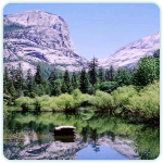
Tenaya Lake
Its clear alpine waters surrounded by massive domes of polished granite, Tenaya Lake was named Pywiak — “lake of the shining rocks” — by the native Americans who once lived there. Lovely picnic spots dot the road along the lake’s northern shore, and fishermen angle for trout from motorless boats. Many visitors, lured by some of the finest rock climbing available anywhere in the country, scale nearby Pywiak Dome, Stately Pleasure Dome, and other rounded peaks.
Tuolumne Meadows
As Tioga Road ascends from Tenaya Lake, it heads east past Medlicott Dome, Fairview Dome, and other granite peaks. At about 8,600 feet above sea level, the drive reaches Tuolumne Meadows, the largest subalpine meadow in the Sierra Nevada, where rolling grassland provides a pleasing contrast to the greatest concentration of granite domes in the world. Numerous ponds and streams attract mule deer, black bears, coyotes, and other wildlife. The area’s natural wonders are best appreciated along the network of trails — such as the Pacific Crest Trail, the trail to Elizabeth Lake, and the John Muir Trail to Cathedral Lakes — that lead from the visitor center.
Tioga Pass
With Lembert Dome visible to the north, the route runs alongside the Dana Fork of the Tuolumne River and climbs through forests toward Dana Meadows and Tioga Pass. At 9,945 feet, Tioga Pass is the loftiest highway pass in all of the Sierra Nevada. At its summit sits the eastern entrance to Yosemite National Park. A mile-long trail leads through forests to sparkling Gaylor Lakes to the west.
Lee Vining Canyon
From Tioga Pass the drive descends eastward past creeks that attract trout fishermen and meadows that offer views of rock wrens, bobcats, and yellow-bellied marmots. The road skirts Tioga and Ellery lakes, then spirals down the slopes of Lee Vining Canyon. Between lofty Tioga Pass and the desert town of Lee Vining, the road drops some 3,000 feet in about 14 miles. To the east an impressive panorama takes in the arid landscape below, including the Mono Craters, a chain of dormant volcanoes, and the snowcapped White Mountains in the distance.
Mono Lake
Just northeast of Lee Vining lies a natural wonder unlike any other on the drive: ancient and mysterious Mono Lake. Nestled in a basin of sagebrush, with volcanic hills rising around its borders, the salty, million-year-old body of water is bedecked with bizarre natural statues, called tufa towers. The exquisite calcite sculptures were formed under the surface when carbonates in the water combined with calcium from freshwater springs feeding into the lake. Over time the hardened minerals piled up inch by inch, forming hundreds of knobs, spires, and minarets. This surreal moonscape is a wonderland for birds. The salty water , much denser than seawater, affords swimmers a delightful sensation of buoyancy. Concluding the drive with a potpourri of eerie marvels, Mono Lake serves as an intriguing coda to the splendor and spectacle of California’s Yosemite National Park.