
George Parks Highway: Alaska: USA
George Parks Highway
Threading through the land of the midnight sun, this wilderness ramble reveals the many facets of Mt. McKinley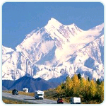 (Denali), the icy jewel in Alaska’s craggy crown. To explorer George Vancouver, who sailed into the upper Cook Inlet in 1794, the crests of Mt. McKinley and its attendant peaks were “distant stupendous mountains.” These wonders remain as awesome as ever, but thanks to the George Parks Highway, completed in 1971, they are now within easy reach of their admirers.
Palmer
Ice sculpted the face of Alaska, and the chisel marks are visible in the very first leg of this dramatic drive. Heading northeast from Anchorage, the Glenn Highway (Rte. 1) crosses two ice-fed rivers — the Knik and the Matanuska — en route to Palmer, gateway to the glacier-gouged Matanuska and Susitna valleys.
The colossal sheet of ice that covered this region some 12,000 years ago has long since retreated, but the silt and soil it left behind make the Mat-Su Valley (as the two valleys are jointly called) a veritable 15,000-acre vegetable garden. With daylight stretching to 19 hours and 21 minutes at the summer solstice, local farms turn out radishes the size of softballs and cabbages weighing as much as 90 pounds. You can find this produce at roadside stands throughout the summer or at the annual Alaska State Fair, which is held in Palmer during the 10 days before Labor Day.
The area north and east of town is laced with hiking trails that afford good views of snowcapped Pioneer Peak, named to honor some early emigrants from the Lower 48. In 1935, 202 families moved here from Depression-ravaged farms in Minnesota, Michigan, and Wisconsin to form the Matanuska Colony, a New Deal agricultural collective believed to be the first and only one of its kind in America. Hence the area’s gabled barns are more reminiscent of Midwestern dairy farm architecture than they are of north-country homesteads.
Hatcher Pass
Just north of Palmer, the drive jogs west for a wilderness detour to Hatcher Pass. About 10 miles up Palmer-Fishhook Road, where the pavement gives way to gravel, the route enters a gorge and begins climbing through stands of willow, spruce, and birch that border the Little Susitna River. This stream once yielded gold but now is prized instead for its silver salmon. The fish swim upstream on their spawning runs from late July through August.
Farther up the road is Independence Mine State Historical Park, where exhibits recall the heyday of drill-and-blast gold mining. Hiking trails thread the 1,000-acre park and overlook the lake-pocked floor of the Mat-Su Valley below. Two miles west of the park, the side trip reaches its scenic highlight: 3,886-foot-high Hatcher Pass, which serves as the cross-country training center for the U.S. Ski Team.
Situated 1,500 feet above the tree line, this alpine enclave features hanging valleys, scooped-out cirques, and meadows carpeted in the summer months with bluebells, chocolate lilies, low-bush cranberries, and forget-me-nots. Sweeping vistas take in Summit Lake, to the west, and the surrounding Talkeetna Mountain range.
Wasilla
From Hatcher Pass the drive does an about-face and retraces part of its path to Wasilla, a hamlet that hugs the shores of two long, narrow lakes. Turn off the highway near the center of town for a picnic at Lakeshore Park, which offers winter skating, summer swimming, and year-round views of the crenelated Chugach Mountains.
Founded in 1917 as a station on the Alaska Railroad, which links Anchorage and Fairbanks, Wasilla is now the biggest town between those two cities. About 10 miles east of Wasilla, the George Parks Highway (Rte. 3) intersects with the Glenn Highway. Named for the man who governed the Alaska Territory from 1925 to 1933, this paved artery runs north into the rugged heart of the state.
Wasilla is also along the route of the annual Iditarod Trail Sled Dog Race, sometimes referred to by locals as the Last Great Race on Earth. In early March solo mushers drive dog teams about 1,100 miles from Anchorage to Nome. Visitors who miss the race can catch it on video at the Iditarod Headquarters, a log cabin museum located two miles south of town on Knik Road.
This museum chronicles the colorful history of the event, which commemorates a race against disaster: in 1925 a relay of heroic dog teams traveled 674 miles in about 127 hours to deliver serum to diphtheria-threatened Nome on the Arctic Ocean. Dog racing is also the theme of the Knik Museum and Sled Dog Mushers Hall of Fame, located at mile 13.7 on the Knik Road.
Big Lake
From Wasilla the drive proceeds due west, snaking through low, level terrain all the way to the turnoff for Big Lake. A short side trip leads to three state recreation areas (Big Lake North, Big Lake South, and Rocky Lake) supplied with campgrounds and picnic sites. Although Big Lake is just five miles long, it is the largest of the dozen or so ponds that glaciers created in the lower Mat-Su Valley. Man picked up where the ice left off, dredging waterways that connect Big Lake to several of its smaller siblings. You can explore this network’s 53-mile shoreline by powerboat, paddle-wheeler, or canoe. Tranquil waterside views are available from restaurants that front the lake.
Nancy Lake State Recreation Area
Back on Rte. 3, the drive curves northwest toward Willow. Shortly after crossing the train tracks at mile 66.5 (the Parks Highway parallels the Alaska Railroad), Rte. 3 intersects a spur road leading into Nancy Lake State Recreation Area. This swampy but scenic domain, covering nearly 23,000 acres, is studded with some 130 lakes.
Nancy Lake Parkway, the area’s gravel access road, meanders through forests of spruce, birch, and aspen inhabited by moose, black bears, and coyotes. Sandhill cranes have been known to perform their elaborate springtime courtship ritual within view of the road, and common loons often can be glimpsed on the canoe trail that stitches together 22 of the area’s lakes (canoes can be rented at the South Rolly Lake Campground).
Returning to the highway, the drive passes through Willow, a lazy little town that almost became Alaska’s state capital during the 1970s, when a move from Juneau was considered but never carried out. Willow lost its shot at glory but held on to a more eternal claim to fame: it is here that travelers heading north on the Parks Highway often catch their first glimpse of mighty Mt. McKinley, which reigns supreme over the 600-mile-long Alaska Range.
Talkeetna
During climbing season — May and June — mountain fever reaches its peak in Talkeetna, a town that serves as a springboard for expeditions to Mt. McKinley, some 60 miles to the northwest. Weather permitting, one of the best views of the mountain comes at mile 13 on the Talkeetna spur road, which branches northeast from the highway at mile 98.7.
At 20,320 feet high, Mt. McKinley is North America’s loftiest pinnacle. But what makes the mountain so daunting to scale is not its height but its climate. Thin air, frigid temperatures (even in summer), and winds gusting up to 150 miles per hour make McKinley’s upper reaches one of the most forbidding places on earth. In spite of such danger, about a thousand people per year try to reach its summit; in a good year, half of them succeed.
Denali State Park
Back on Rte. 3, the drive passes through a white-and-green grove of birch trees intermixed with ferns that stretches all the way to the Susitna River bridge and beyond. From here north, the terrain gradually shifts from the open valleys of south-central Alaska to the icy escarpments of the interior. Nowhere is this change more dramatic than in Denali State Park, a 324,000-acre wilderness preserve that lies in the shadow of Denali National Park. Turnouts throughout the state park afford views of Mt. McKinley and the mammoth glaciers — notably Ruth, Buckskin, and Eldridge — that inch their way down the southern flanks of the McKinley group, sometimes coming within five miles of the road.
Hurricane Gulch
With so many natural wonders at every turn, it’s easy to forget that Alaska also harbors its fair share of man-made marvels. A prime example of these is the bridge at Hurricane Gulch, a 260-foot-high, 558-foot-long span across the widest and deepest gorge on the George Parks Highway. Built in 1971, the bridge is in turn eclipsed by the railway trestle to the west, which is 36 feet higher, 360 feet longer, and 50 years older.
Broad Pass
After vaulting Honolulu Creek, the drive takes aim for a breach in the wall of the Alaska Range and enters Broad Pass, the pivot point for a panorama of peaks that soar nearly 12,000 feet skyward. Broad Pass divides the east and west segments of the Alaska Range. Forming part of the Continental Divide, these majestic mountains segregate rivers to the south, which flow into the Gulf of Alaska, from those to the north, which empty into the Yukon River.
Denali National Park
Some call it the Denali dilemma: in spite of its size (6 million acres — an area larger than the state of Massachusetts), the park has so many visitors (about 600,000 per year — nearly equal to the population of Alaska) that it must limit access to protect its fragile wilderness. This spirit of preservation has been a hallmark of Denali National Park since its inception.
In 1906 hunters in the foothills of Mt. McKinley were eradicating the Dall sheep, shaggy white critters with curlicue horns, at an alarming rate. Outraged, conservationist Charles Sheldon launched a campaign to save the animals. On February 26, 1917, his efforts finally paid off; President Woodrow Wilson signed a law that brought Mt. McKinley National Park into existence, saving it for perpetuity.
Three boundary expansions and one name change later, Denali National Park remains a pristine wildlife sanctuary that is home to 38 kinds of mammals and 158 species of birds, which migrate here from several continents. To protect the preserve, the park prohibits cars beyond the Savage River, 15 miles west of Rte. 3 on the park road. Shuttle buses departing from the visitor center cover the final 70 miles to Wonder Lake. If you can’t spare the two or three days it may take to get a bus pass during the summer, try to catch a glimpse of Mt. McKinley between miles 9 and 11 of the park road.
Even from 70 miles away, you’ll easily see why Alaskan natives dubbed the peak Denali, “The Great One.” The mountain towers more than 18,000 feet above the surrounding lowlands, making it, when measured from base to summit, even higher than Mt. Everest. Yet McKinley’s majesty is often veiled by a mist: warm, moist air from the Gulf of Alaska condenses on the mountain’s southern face, creating a steady drizzle that obscures it from view two days out of three.
Wonder Lake
At the visitor center sightseers board a bus to Wonder Lake. Although the road never rises above 4,000 feet, it offers a wealth of scenic high points. Sable Pass, at mile 39, is the surest place to spot grizzly bears, which are so fond of the wildflowers and berries here that a mile-wide zone on either side of the road has been closed to hikers since 1952.
Continuing west, the route clambers up Polychrome Pass, named for its rainbow of mineral-rich rocks. Tinged pink, red, orange, yellow, rust, and purple by exposure to the air, these stony outcroppings frame a southerly view of glacial handiwork: kettle lakes, erratics (isolated boulders), and the braided East Toklat River. You can get off the bus and start hiking almost anywhere, but the best place is the Eielson visitor center (mile 66).
In the summer a naturalist leads a “tundra trek” — a chance to identify some of the park’s 430-plus kinds of flowering plants. The visitor center also affords prime views of Mt. McKinley and Muldrow glacier, extending 32 miles and almost three miles of elevation. Save film for Wonder Lake — sunrise and sunset bathe Mt. McKinley in hues of pink and purple.
Nenana
After returning from the Eielson visitor center (an eight-hour round-trip bus ride) or Wonder Lake (11 hours round-trip), resume the drive behind the next 65-mile stretch, which meets the scenic gorge of the Nenana River, is riddled with sharp turns, windy passes, canyon crossings, and frost heaves (dips and blips in the pavement caused by moisture freezing in the soil beneath the road surface). Nenana means “a good place to camp between two rivers,” and the name is certainly apt. The town’s setting is the confluence of the Tanana and Nenana rivers. About 20 miles north, the route reaches Skyline Drive, running along the ridgetops with spectacular views.
Fairbanks
As the drive crosses the Chena River, the land levels out and Fairbanks spreads out along eight miles of the river’s banks. A boisterous bit of civilization amidst Alaska’s wilderness, birch-blanketed hills surround the town; climb those to the north and west for good views of the Tanana River valley. One such vantage point is the 2,250-acre campus of the University of Alaska, which perches on a grassy ridge four miles west of Fairbanks. In addition to its cultural museum, botanical garden, and musk-ox farm, the university affords one last look at Mt. McKinley, now a distant vision on the far horizon, if your luck is good and its ever-present clouds part, giving you a clear view.