
Loneliest Road in America: Nevada: USA
Loneliest Road in America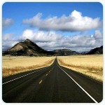
The desert of central Nevada — for the most part unforgiving and remote — has a silent grace that remains unbroken but for historic sites and a two-lane highway.
Galloping at a tear, brave riders of the Pony Express once carried mail to the West Coast along the very course now followed by Rte. 50. Often traveling for long stretches with not another living soul in sight, their journeys led them through an inhospitable land of sand and peaks-the Great Basin.
The region, however, has changed since those early times, today offering travelers friendly towns and conveniences. So when Rte. 50 is called the Loneliest Road in America, take it with a grain of salt and enjoy an area as rich in lore as the hills once were in ore.
Lake Tahoe
Deep blue and surrounded by evergreen forests and snowy peaks, Lake Tahoe offers one last lush treat before you set off on this trek through mostly stark terrain. The views from Rte. 50, which wends along the eastern shore, occasionally open up to reveal the vastness of the lake. Perched at an altitude of more than a mile, Tahoe has sparkling clear water, with depths of up to 1,645 feet. For a fine panorama, take a ride to the top of the mountain on the Heavenly Gondola in South Lake Tahoe — site of Nevada’s largest ski resort.
Carson City
With the High Sierra in the rear view mirror, the drive leads to Carson City, the state’s capital, which was named for frontiersman Kit Carson. While much of the land seems barren, looks are deceiving; the region has great biodiversity and yields a wealth of precious minerals.
In fact, one of the richest veins of silver and gold ever discovered, the famed Comstock Lode, was unearthed in nearby Virginia City, luring miners by the thousands in the mid-1800’s.
A small city sprang up almost overnight, and as area mines began to pay off, tycoons set about building impressive mansions. One of the earliest, the Bowers estate, still stands some 10 miles north of town; made of granite, it cost $200,000 to build and furnish in 1864, then a staggering sum.
Dayton
Rte. 50 runs on one long strip to the northeast, crossing a sagebrush plateau on the way to Dayton. In earlier times the town was a Pony Express station and the site of Nevada’s first gold strike. Virginia City, about seven miles to the north via Rte. 341, was nicknamed the Queen of the Comstock. Historical tours are available of the former boom town, once home in the mid-1800’s to some 25,000 people, including a young reporter with the pen name Mark Twain. Among the many restored buildings are mansions, churches, banks, saloons, and an opera house.
Fort Churchill State Historic Park
With the silence of the desert intensifying, sagebrush and sand are constant companions as the road continues on toward Fort Churchill, reached by a short side trip to the south. The old adobe army post was built in 1860, then abandoned nine years later. A visitor center tells the fort’s story, but it is among the crumbling walls that sightseers can most palpably feel the isolation of the place, especially when the wind whips by. The Lahontan State Recreation Area, with boating and swimming, lies to the east. Its lake, an oasis in a land that averages less than six inches of rain per year, owes its existence not to the forces of nature, but to the ingenuity of man.
Fallon
Silver and gold may have inspired the settlement of towns such as Dayton, but it was water — thanks to the Lahontan Reservoir — that gave Fallon its start. Fields of alfalfa ring this island of greenery, and its quiet neighborhoods boast manicured lawns and shady streets.
To the northeast Stillwater Wildlife Management Area and Refuge, with more than 224,000 acres, offers sanctuary to hosts of birds, including cinnamon teal, redheads, and whistling swans. Grimes Point Archaeological Area, about eight miles to the east, holds several hundred boulders carved with prehistoric designs.
Although archaeologists have yet to decipher the images, most speculate that the petroglyphs tell of hunts and seasonal variations. Here, you can also spot some of our country’s newest and fastest jets taking off from the Fallon Naval Air Station.
Sand Mountain
As the highway leads east, it dips into the dry bed of an ancient sea; then 15 miles farther, Sand Mountain, a large dune, looms above the flatlands. The sculptural formation, about two miles long, rises an abrupt 600 feet.
At one end of its base lie stone walls, the ruins of a Pony Express station. The Pony Express, though long on legend, was short on life. No matter how fast the horses ran and how hard the riders pushed themselves, together they could never match the speed of the transcontinental telegraph.
Virtually overnight, what had taken days by pony could be sent in seconds by wire. On October 24, 1861, a scant 18 months after start-up, the Pony Express was dissolved.
Austin
Bare, bold mountains and sagebrush desert characterize the remote stretch of Rte. 50 that leads onward to Austin. Although this area may appear lifeless, the relative stillness is broken by such animals as snakes, lizards, coyotes, and jackrabbits — all more active by night than during the day.
Flying above, however, are some of the more conspicuous denizens of the desert, including ravens, hawks, eagles, and occasionally, flocks of horned larks. Historic Austin, with views of the Toiyabe Range, was another of Nevada’s silver mining boom towns.
It sprang up in 1862 and quickly became one of the state’s most populated areas. Unlike many mining towns that went bust before soundly constructed buildings could be erected, Austin offers a number of surviving structures, including lovely early churches.
Three pioneer sanctuaries, their bricks stacked high against the sweep of sky, make the town a welcoming, historical sight. And just outside town, down a twisting canyon road, lies a huge stone fortress, Stokes Castle, the fanciful creation of a mining baron.
Eureka
The road out of Austin soon climbs to Austin Summit, a pass perched at an elevation of 7,484 feet. To the southeast rises Hickison Summit, where visitors can picnic on the lower slopes and enjoy views and petroglyphs.
Antelope Peak and Summit Mountain punctuate the eastern horizon, both more than 10,000 feet high. Continuing on to Eureka, you’ll feel your engine alternately strain and sigh as Rte. 50 crosses ridge after ridge.
Eureka itself, nestled in a valley among these peaks, is one of the state’s best-preserved mining towns. Its buildings, made with bricks to avoid the fires that had ravaged earlier wooden structures, include an old newspaper office (now a museum), an 1880’s opera house, and a well-restored courthouse that is still in use.
Ely
After a 77-mile drive past grazing grounds — more peaks and sage-covered valleys — the drive enters Ely, a onetime mining center. Here, though, copper was the treasure, and an amazing 22,000 tons of ore per day were scooped from the ground. Like the silver lodes to the west, however, copper is no longer mined here. Stop at the Nevada Northern Railway Museum, one of the most complete of its kind. Antique locomotives, passenger cars, and offices are on display. The trains set out on regularly scheduled tours-a pleasant way to conclude a visit to the Loneliest Road in America.