
Magnificent Mt. Rainier
Magnificent Mt Rainier Like jewels on a necklace, the premier attractions at Mt. Rainier National Park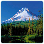 Longmire, Paradise, the Grove of Patriarchs, Sunrise and other locales – are linked by a single winding road that enters the park at its southwestern corner, zigzags up and down canyons and forested slopes, and swings around to the northeastern side of the mountain. Among the sights you’ll see along the way are massive glaciers, sub-alpine meadows, thundering waterfalls, ancient stands of first-growth timber, and — reigning over all — the sleeping giant volcanic peak that Washingtonians affectionately refer to as simply “the mountain.”
Mayfield Lake
Heading east through the farm country between I-5 and Mayfield Lake, Route 12 affords views of three lofty and nearby Cascade peaks; Mt Rainier to the northeast. Mt. Adams to the southeast, and Mt. St. Helens to the south.
Elbe
The drive turns north onto Route 7 at Morton and leads to the little town of Elbe, home base for the Mt. Rainier Scenic Railroad. Steam-powered, with open cars and restored coaches, the train chugs through forests on a 14-mile round-trip to Mineral Lake.
Nisqually Entrance
Viewed from a few miles away, Mt. Rainier appears to hover in the sky like a massive mirage. The 14,422-foot-high dormant volcano, the loftiest in the Cascades, is the majestic centerpiece of Mt. Rainier National Park. From the Nisqually Entrance on Route 706 — the park’s main access point — the road winds through towering Douglas firs and beautiful stands of red cedars to Longmire, where a museum and the well-marked Trail of the Shadows introduce visitors to the history and natural wonders of the lowland forest.
Cougar Rock
From Longmire the road climbs through lush mountain growth to Cougar Rock, one of the park’s major campgrounds. About a mile-and-half farther on, pause to look at graceful Christine Falls.
Narada Falls
Here the Paradise River hurtles off an old eroded lava flow, plunging 168 feet to the valley floor.
Paradise
As the road climbs ever higher, the forest thins out, yielding to sub-alpine meadows and clear views of Mt. Rainier’s upper slopes. Beauty and accessibility have made Paradise the most popular destination in the park.
Stevens Canyon Road
Beginning at Inspiration Point, an overlook that affords an impressive view of Mt. Rainier, this beautiful road scales canyon walls, skirts lakes and waterfalls, winds south and then north again along Backbone Ridge, and ends in the park’s southeasterncorner. Along the way are the glacier-gouged Reflection Lakes, so named because their still surfaces provide clear mirror images of Rainier’s gleaming summit. W h e re Stevens Canyon Road crosses the Cowlitz River, churning water has etched a deep chasm in the volcanic rock. A bridge spans the narrow gorge, which is known as Box Canyon. From the top of the bridge, visitors can gaze at the roiling river some 180 feet below.
Ohanapecosh
Near the Stevens Canyon entrance to the park, two trails invite visitors to stroll through the stately old-growth forest of the Ohanapecosh River valley. The Grove of the Patriarchs Trail winds for a mile and a half through stands of enormous Douglas fir, western hemlock, and western red cedar that are believed to be some 1,000 years old. Another rewarding trail is the three-mile loop to Silver Falls, where the waters of the Ohanapecosh River gush through a slot in ancient volcanic rock and then plunge into a deep, turbulent pool.
Sunrise
Much of the road between Ohanapecosh and Sunrise runs steadily north along the banks of creeks, with Rainier’s gleaming icecap looming to the west. Beyond the park’s White River entrance, an especially scenic spur zigzags upward and emerges on subalpine meadows at Sunrise, the highest point in the park accessible by car. Its most prominent vista takes in nearly four-mile-long Emmons Glacier, the largest glacier in the lower 48 states. Botanical exhibits and a scale model of Mt. Rainier are featured at the Sunrise visitor center.
Mather Memorial Parkway
After twisting and turning downhill from Sunrise, the drive reconnects with Rte. 410, known as Mather Memorial Parkway. Following this route south and turning east at lofty Cayuse Pass, the drive eases along hairpin turns to Tipsoo Lake, a gemlike, glacier carved basin near Chinook Pass. From there, the route heads east out of the park, through the Naches Valley (prime apple-growing country), and to Yakima.