
North Cascades Loop: Washington: USA
 North Cascades Loop This drive takes travelers through volcanic peaks, glacial lakes, sun-drenched farm fields and misty coastal islands.
Sedro-Woolley
This logging town, whose enigmatic name combines the Spanish word for cedar (cedro) with the surname of one of its early settlers, serves as the gateway to the North Cascades. Known as America’s Alps, the mountain range is beautifully preserved in North Cascades National Park — 505,000 acres of fragrant forests, flower-strewn meadows, imposing mountain peaks, intriguing wildlife (bears, wolves, cougars, deer, ptarmigan — a subarctic grouse — and more), and 318 glaciers (about half the total to be found in all of the lower 48 states). A park information center on the western edge of Sedro-Woolley helps visitors get off to an informed start in their explorations of the region.
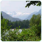
Baker Lake
At Concrete head north off the North Cascades Highway (Rte. 20) and follow a U.S. Forest Service spur to 9-mile-long Baker Lake. A recreational reservoir east of snow-capped Mt. Baker — a 10,778-foot volcano that on occasion still spews out clouds of steam — the lake is a popular place for hiking, sailing, canoeing, and angling for trout, salmon, and whitefish. In spring Baker Lake attracts the state’s largest gathering of ospreys, which return every year to nest.
Rockport State Park
A mecca for hikers, campers, and picnickers, Rockport State Park contains groves of old-growth Douglas fir up to 300 feet tall. More than five miles of trails crisscross the park, some allowing close-up views of wetlands and the forest understory, and others leading to sunny overlooks.
Skagit River Bald Eagle Natural Area
Between Rockport and Marblemount, Rte. 20 passes the Skagit River Bald Eagle Natural Area — some 1,500 acres that have been set aside as a sanctuary for the hundreds of bald eagles that arrive in late fall. From their perches in cottonwood trees along the banks of the river, the birds eye the water, then dive for salmon and steelhead. Visitors can view the birds from river rafts (launched from Marblemount) or from various turnouts along the route.
Gorge Creek Falls
Emerging from a 500-foot-long tunnel, Rte. 20 rejoins the Skagit River and soon arrives at Gorge Creek, which cascades hundreds of feet over ledges and boulders. For a thrilling perspective on the stream, stand on the steel bridge and peer through the grating into the turbulent water 900 feet below.
Diablo Lake
The lake is remarkable for its jade-green color, which is caused by glacial flour (suspended rock sediments that refract the light). Visitors can cruise the man-made lake by motor launch — part of a tour of the hydroelectric facilities offered by Seattle City Light. The trip includes a ride on an incline railway that inches up steep Sourdough Mountain. For magnificent views of the gemlike lake, the dam, and the glacier-honed peaks that encircle them, drive to the overlook on the southeastern shore of the lake. For a hiker’s perspective, take the Thunder Creek Trail, which begins at the Colonial Creek Campground and weaves through miles of dense forest.
Ross Lake Overlook
A few miles to the east of Diablo Lake, one can see the southern arm of Ross Lake — an immense, 12,000-acre body of water that snakes some 25 miles through the mountains to the Canadian border. From here Rte. 20 swings south through Okanogan National Forest, where visitors can ride horses and burros on backcountry trails.
Rainy Pass
Rte. 20 climbs gradually toward Rainy Pass, which at 4,855 feet is one of the finest lookout points in the area. Here the highway crosses the Pacific Crest National Scenic Trail — a hiker’s paradise that extends from Canada to Mexico. A paved trail leads to deep blue Rainy Lake, where visitors can gaze at a waterfall, a glacier, and the surrounding peaks. In fall the bright golden leaves of mountain ash are mirrored in the lake.
Whistler Basin Overlook
In spring the melting snow on Whistler Mountain feeds waterfalls that cascade down steep slopes into Whistler Basin. In summer the nearby alpine meadow is thickly quilted with wildflowers. Be on the lookout for deer, marmots, and pikas — especially in the early morning hours and at dusk.
Washington Pass
From an overlook just off this 5,477-foot pass — the highest on the North Cascades Highway — the view to the south is dominated by the crags of Liberty Bell Mountain, which towers to a height of 7,720 feet. Here too, travelers can review the damp, forested mountains they’ve left behind and anticipate the sunny slopes and dry valleys that lie ahead, east of the mountains. The road descends in a series of hairpin turns, with avalanche chutes visible along the highway.
Winthrop
Poised at the fork of the Methow and Chewuch rivers, this tiny town was founded in the late 1800s and seems to have retained its frontier appearance. The old-fashioned facades, however, are actually false fronts erected in 1972 to promote tourism. The allure here owes as much to the weather as to the architecture: the valley basks in sunshine some 300 days a year, and so it is a mecca for all manner of outdoor activity — from camping and hiking to mountain biking, snowmobiling, and cross-country skiing.
Wildflowers and wildlife — countless acres of lupine, larkspur, and mariposa lilies, along with mule deer, songbirds, and waterfowl — thrive in this climate too. Nearby are 578-acre Pearrygin Lake State Park, which flanks a spring-fed lake with a bright, sandy beach, and Big Valley Ranch, a former cattle ranch that is now a wildlife preserve.
Lake Chelan
The loop leads southward now, meandering down Rte. 153 through the fruit orchards, horse ranches, and hayfields of the Methow River valley toward Lake Chelan. Cradled in a narrow glacial trough between the Chelan Mountains and Sawtooth Ridge, the long, narrow, sapphire-blue lake is up to 1,500 feet deep.
At the southern end the resort town of Chelan serves as the launch point for excursion boats and seaplanes to Stehekin, a 19th-century mining community 55 miles uplake and inaccessible by road. Private farms along the lower shoreline yield at midlake, becoming a mix of forest and rugged bluffs scaled by mountain goats. At the northern tip lies the Lake Chelan National Recreation Area, a wilderness laced with hiking trails.
Wenatchee Valley
The Wenatchee area calls itself the Apple Capital of the World, and the claim makes sense: its enormous annual crop of apples is greater than the number produced by any other apple-growing locale. In spring, mile after mile of orchards are suffused with delicate white-pink blooms; in fall, the trees hang heavy with red and golden globes.
Beautiful Ohme Gardens, in the town of Wenatchee, was begun by an orchardist in 1929 as a family retreat. Situated on nine acres of rock outcroppings high above the valley, the gardens are a harmonious blend of evergreens, alpine flowers, stone paths, and tranquil pools — all enlivened by chirping birds and scampering rabbits.
In nearby Cashmere visitors can tour an authentically restored 19th-century pioneer village or stop by a popular candy factory to witness how Aplets and Cotlets, renowned local confections, are fashioned from apples, apricots, and nuts.
Leavenworth
On the verge of becoming a ghost town a few decades ago due to a loss of industry, Leavenworth reinvented itself as a village embodying all the charm and flavor of the Bavarian Alps. Half-timbered and balconied chalets and frescoed facades line the flower-bedecked streets, and merchants in traditional lederhosen or dirndls proffer frosty steins of Bier and steaming plates of Wurst. Leavenworth is also a prime location for white-water rafters and kayakers, who shoot the challenging Wenatchee River rapids found along the river’s course between the towns of Leavenworth and Cashmere.
Tumwater Canyon
For several miles the drive parallels the Wenatchee River as it passes through Tumwater Canyon. Although the trees here are usually resplendent with fall color, about one-third of them were consumed by fires in the summer of 1994. At Coles Corner, Rte. 207 leads to five-mile-long Lake Wenatchee, a pristine gem fringed with beaches, boat launches, and picnic spots.
Stevens Pass
Though rare and elusive, mountain goats can sometimes be seen from the highway at 4,061-foot Stevens Pass, an area popular with skiers in winter. For an unusual hike that combines glorious scenery with a glimpse into railroading’s past, visit the Iron Goat Trail, which traces the route of the old Great Northern Railway for several miles below Stevens Pass. You can reach the trail by turning north onto the Old Cascade Highway and then taking Rte. 6710 to the trailhead. A few miles to the west, near Skykomish, Deception Falls thunders down the mountainside and under the highway bridge.
Mt. Index
Jagged and forbidding, 5,979-foot Mt. Index is graced by high waterfalls that appear as silvery threads from the highway. In the mountain’s shadow, the turbulent Skykomish River (known locally as “the Sky”) poses challenges to white-water rafters, and a gentle invitation to anglers casting for salmon and steelhead.
Wallace Falls State Park
In the timbered foothills outside of Gold Bar lies Wallace Falls State Park. A trail here winds to the brink of a tumbling 265-foot waterfall, rewarding hikers with stunning views of both the Skykomish Valley and nearby Mt. Baker-Snoqualmie National Forest.
As Rte. 2 follows the Skykomish River downstream towards the ocean, the rugged highlands of the Cascade Range gradually give way to the rocky coastline typical of the coast along the inland waters of Puget Sound. At the port town of Everett, visitors can glimpse the swarms of ferries mixed with pleasure craft that ply the waterway, and hear the plaintive doglike barks of the many Steller sea lions that bask on the beaches and many offshore rocks of Everett Jetty Island.
Whidbey Island
The turn-of-the-century lighthouse at Mukilteo recedes from view as the ferry chugs across Possession Sound to Whidbey Island, with its charming towns and cliff-backed coves. The bayside village of Langley is a favorite weekend getaway for local urbanites, who come to stroll streets lined with boutiques, antique shops, and galleries. For a somewhat “wilder” environment, head to South Whidbey State Park, a 340-acre habitat for old-growth Douglas firs and red cedars, as well as eagles and black-tailed deer.
Farther up-island, at Fort Ebey State Park, a fortification dating from World War II surrounds what many locals consider the prettiest beach on Whidbey Island: Partridge Point. For views of the Olympic Mountains and Mt. Rainier framed by boughs of pine and fir, you can take the Ebey’s Landing Loop Trail, which traverses windblown bluffs and paths lined alternately with driftwood and wild roses.
Deception Pass Bridge
Linking Whidbey with its northern neighbor, Fidalgo, this 1,487-foot steel cantilever bridge stands above a narrow neck of water where tides swirl and surge around the rocks. Below, a state park embraces some 4,067 acres of forests, marshlands, freshwater lakes, and beaches on the sound. Both the bridge and park offer stunning views of Puget Sound — populated by porpoises and otters and dotted with some 200 enchanting islands.
Fidalgo Island
At the northern end of Fidalgo Island, the port town of Anacortes bustles with ferries, charter fleets, and pleasure boats — it’s a favorite spot for salmon fishermen in summer. From the top of 1,270-foot Mt. Erie, the highest point on the island, the busy maritime scene reminds one of toy boats on a gleaming blue pond. Continuing on Rte. 20 to the mainland, the Cascade loop ends where it began — in the fertile Skagit Valley. Here the moist lowlands abound with truck and dairy farms and are abloom each spring with whole fields of daffodils, irises, and the world’s largest crop of tulips.